Property Record
3137 Salem Ave, Dayton, OH 45406
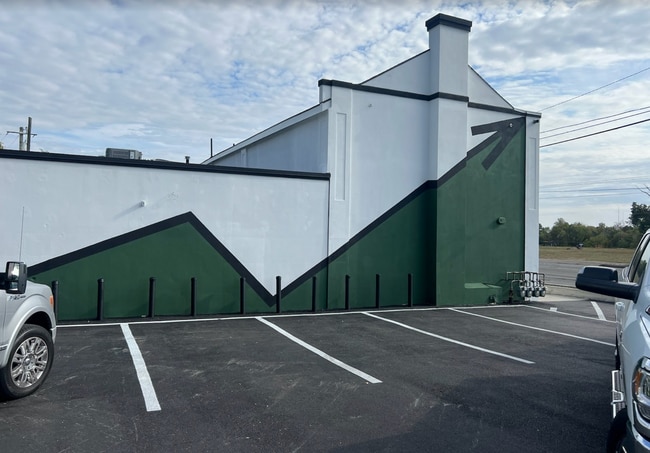


Property Detail
3137 Salem Ave
Dayton, OH
72381
R72-16307-0012
Montgomery
Storebuilding
Ohio
B and X Area of moderate flood hazard, usually the area between the limits of the 100-year and 500-year floods.
12
2024
0.29 AC
2025
North Dayton
000500
Cincinnati/Dayton
6,355 SF
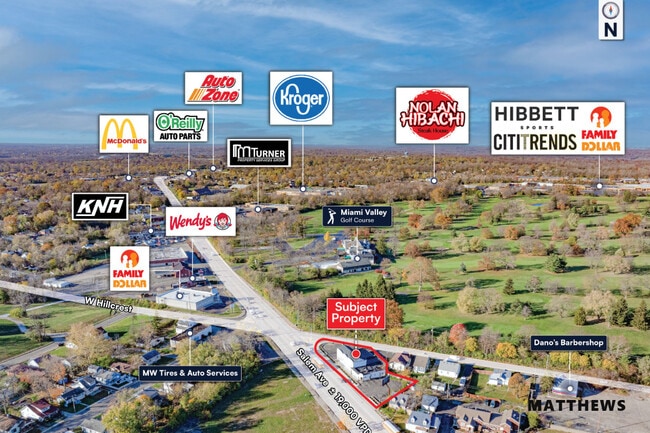
NEARBY LISTINGS FOR SALE OR LEASE
DEMOGRAPHICS near 3137 Salem Ave
1 mile
3 mile
5 mile
2025 Total Population
13,062
85,471
165,689
2030 Population
13,374
88,474
170,095
Pop Growth 2025-2030
+ 2.39%
+ 3.51%
+ 2.66%
Average Age
40
40
39
2025 Total Households
5,808
37,911
71,193
HH Growth 2025-2030
+ 2.38%
+ 3.45%
+ 2.71%
Median Household Inc
$47,593
$42,739
$45,486
Avg Household Size
2.20
2.20
2.20
2025 Avg HH Vehicles
1.00
1.00
1.00
Median Home Value
$75,285
$79,886
$102,616
Median Year Built
1954
1954
1957
Nearby Places
Map Layers
Map Styles
 Street
 Aerial
Transit
 Traffic
 Biking
Places
Listings with unknown addresses are not visible on the map
- Restaurants
- Banks
- Shops
- Fitness
- Groceries
PUBLIC TRANSPORTATION
AIRPORT
James M Cox Dayton International
Drive
Walk
Distance
James M Cox Dayton International
19 min
9.5 mi
SALE & LEASE HISTORY
LISTING DATE
SALE/LEASE

Nov 25, 2024
For Lease
Nov 24, 2025
For Sale
Jun 27, 2024
For Sale
Jun 27, 2017
For Lease
Dec 11, 2024
For Sale
Nearby Properties
Address
Land Use
TOTAL SIZE
Lot Size
Zoning
Address
Land Use
TOTAL SIZE
Lot Size
Zoning
127,232 SF
7.96 AC
Address
Land Use
TOTAL SIZE
Lot Size
Zoning
5.92 AC
Address
Land Use
TOTAL SIZE
Lot Size
Zoning
2.67 AC
Address
Land Use
TOTAL SIZE
Lot Size
Zoning
20.16 AC
Address
Land Use
TOTAL SIZE
Lot Size
Zoning
170,977 SF
8.65 AC
Address
Land Use
TOTAL SIZE
Lot Size
Zoning
100,716 SF
4.31 AC
Address
Land Use
TOTAL SIZE
Lot Size
Zoning
31.16 AC
Address
Land Use
TOTAL SIZE
Lot Size
Zoning
200,000 SF
47.69 AC
Address
Land Use
TOTAL SIZE
Lot Size
Zoning
390,656 SF
47.47 AC
Address
Land Use
TOTAL SIZE
Lot Size
Zoning
6.25 AC
Address
Land Use
TOTAL SIZE
Lot Size
Zoning
220,000 SF
16.34 AC
Address
Land Use
TOTAL SIZE
Lot Size
Zoning
23.29 AC
Address
Land Use
TOTAL SIZE
Lot Size
Zoning
24,530 SF
11.89 AC
Address
Land Use
TOTAL SIZE
Lot Size
Zoning
6.57 AC
Address
Land Use
TOTAL SIZE
Lot Size
Zoning
101,698 SF
19.06 AC
Address
Land Use
TOTAL SIZE
Lot Size
Zoning
11.14 AC
Address
Land Use
TOTAL SIZE
Lot Size
Zoning
6.30 AC
Address
Land Use
TOTAL SIZE
Lot Size
Zoning
9.97 AC
Address
Land Use
TOTAL SIZE
Lot Size
Zoning
243,256 SF
13.58 AC
Address
Land Use
TOTAL SIZE
Lot Size
Zoning
46,592 SF
5.32 AC
Address
Land Use
TOTAL SIZE
Lot Size
Zoning
57,467 SF
5.33 AC
Address
Land Use
TOTAL SIZE
Lot Size
Zoning
68,196 SF
3.55 AC
Address
Land Use
TOTAL SIZE
Lot Size
Zoning
92,782 SF
12.44 AC
Address
Land Use
TOTAL SIZE
Lot Size
Zoning
10.06 AC
Address
Land Use
TOTAL SIZE
Lot Size
Zoning
71,363 SF
4 AC
Address
Land Use
TOTAL SIZE
Lot Size
Zoning
138,450 SF
26.57 AC
Address
Land Use
TOTAL SIZE
Lot Size
Zoning
82,316 SF
13.34 AC
Address
Land Use
TOTAL SIZE
Lot Size
Zoning
235,827 SF
1.65 AC
Address
Land Use
TOTAL SIZE
Lot Size
Zoning
12.89 AC
Address
Land Use
TOTAL SIZE
Lot Size
Zoning
30.98 AC
The World's #1 Commercial Real Estate Marketplace
Connect with us
© 2026 CoStar Group
The information above has been obtained from sources believed reliable. While we do not doubt its accuracy we have not verified it and make no guarantee, warranty or representation about it. It is your responsibility to independently confirm its accuracy and completeness. Any projections, opinions, assumptions, or estimates used are for example only and do not represent the current or future performance of the property. The value of this transaction to you depends on tax and other factors which should be evaluated by your tax, financial, and legal advisors. You and your advisors should conduct a careful, independent investigation of the property to determine to your satisfaction the suitability of the property for your needs.